The roads in Granite State, taken by the author
I lived in the town of Hooksett. It is a town located along route 3 and is not far from Manchester. One of the activities I loved there was driving or riding on a motorcycle. In weekends, I often got out to refresh myself in a fresh air and took my truck or motorcycle to get around Granite State not really knowing where I was heading. It was a good way to relax, just to get ready for work next week. A lot of thoughts could get in your mind, as you drive on quiet mountain routes, that all look endless.
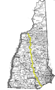
Just to name a few, these are the roads that I took in Granite State. Please note that some of the routes are not written as one trip but as total distance driven on the route.
Highway
Highways are useful, as you can move from area to area in the Granite State very quickly.
![]() Route 93 from Exit 1 to Exit 42
Route 93 from Exit 1 to Exit 42
Route 93 connects to Vermont in north and to Massachusetts in south. It is a major highway
in Granite State, especially if you have to head up north or down south. You can take the
route 93 from Boston, Massachusetts and after an hour or so, you will know that you are in
Granite State. The road sign will welcome you to the state. The first exit you see after
the sign on Route 93N is Exit 1 and is a town of Salem. You would drive through trees and
may think that you are out of nowhere. Surely, the southern part of Route 93N in Granite
State has nothing but a lot of hills. There are some populated areas in between, such as
Manchester and Concord. Don't forget that you have to pay the toll at Hooksett. After
Concord, you will drive through a long straight road between trees and sooner you will
find yourself in larger hills. When you pass Franklin, you should be ready for the scenic
views along the road. Trees have now turned into woods and you are driving in hills again.
You can almost smell water in the air as there are lakes in this region and those areas
are really popular for camping. There are signs for campgrounds along the road. After
Plymouth, you should soon realize that you are seeing mountains rathen than hills. In
fact, it is white mountain region. White mountain is the tallest mountain in Granite
State. In the misty morning, this mountain region along the highway looks really
beautiful. It is one of the beautiful scenes in the State. You will have to drive up these
mountains and then through valleys. Yet, caution is requied when you are driving in the
valleys. Watching scenaries and driving can be dangerous as the highway gets narrower in
the valleys and there are rails that devide lanes. You can see camping or skiing areas on
both sides as you drive through this narrow and winding lane. From this point or above,
the route will be downhill and don't even try to tailgate a car ahead. There is nothing
but mountains around there but the man-faced rock is located in a cliff in this area. As
you go down the mountains,the road gets wider again. Exit 42 is just around the corner.
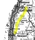
![]() Route 89 from Concord to Lebanon.
Route 89 from Concord to Lebanon.
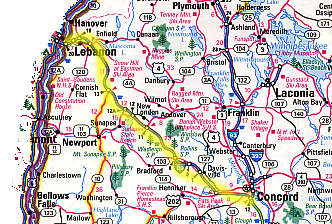
You can get on Route 89 from Route 93 in Concord. It is the route that heads northwest to
Lebanon and up above. If you are rushing to Sunapee Lake region, this route might help but
you won't be able to see much sceneries, other than woods really. It crosses some
mountains too. Lebanon is located at the state border between Vermont and Granite State.
![]() Route 101 Manchester To Hampton Beach
Route 101 Manchester To Hampton Beach
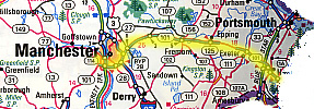
This highway connects Bedford to Hampton Beach. It is rather a stable route since there is
no mountains to cross. Yet, this is not a scenic route.
![]() Everett Turnpike from Bedford to Hudson
Everett Turnpike from Bedford to Hudson
You have to pay the toll to use this turnpike. It should be 75 cents. This is used for the
quick route between Bedford and Massachusetts.
![]() Blue Star Turnpike from Hampton to Portsmouth
Blue Star Turnpike from Hampton to Portsmouth
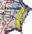
There is the toll for the turnpike. This is a useful route if you have to rush from
Hampton to Portsmouth. The road is wide and straightforward but there is nothing special
along the highway. If you are heading to Portsmouth, you want to get off at Portsmouth
Circle or its business district exit.
![]() Spaulding Turnpike from Portsmouth to Dover
Spaulding Turnpike from Portsmouth to Dover
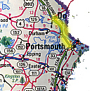
You can get onto the turnpike from the business district of Portsmouth. The
turnpike goes on toward the north and you should be enjoy a beautiful scenery of
Portsmouth coastline, as you go over a bridge.
![]() Route 393 from Concord to Route 4
Route 393 from Concord to Route 4
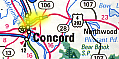
It is an extension of Route 93 to get onto Route 4.
Other Routes
Compared to Highways, public routes has a lot of fun, as you can take a closer look at sceneries and stop by places, whenever you like.
![]() Route ? From Littleton to Lancaster
Route ? From Littleton to Lancaster
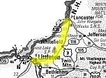
From off the town of Littleton to Whitefield, it is quiet and you can enjoy sceneries. It
is nice to drive up and down hills with windows opened. If you see bikers on the other
lane, you want to cast a hand sign for them as greeting. It is really an easygoing region.
In Whitefield, you may want to have a lunch at a local diner. People around here arealways
friendly. You have to still go up north to head to Lancaster. The route between Whitefield
and Lancaster is scenic. Literally you are driving up and down mountains. When you go down
the mountain, you will realize the beautiful landscape over the town of Lancaster.
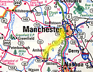
![]() Bypass 28 from Salem to Manchester
Bypass 28 from Salem to Manchester
If you're in the town of Salem and to head to Manchester in north without driving on
highway, you will definitely come across the bypass 28. The road will get you out of the
town quickly and then you will find yourself in areas full of trees. You will have to go
up and down the hill and then get to a traffic circle. Do not get confused there and you
must keep on going straight uphill. If you see a church at an intersection on the right
hand side, you're now in Londonderry area. From this point and above, it can be a scenic
drive, as it is a straight raod that goes under arches of trees. Don't worry about gas.
When you are out of the arches, there is a gas station. You would have to drive a little
longer until you get to Manchester. You will drive under arches of trees again and go
downhill. When you see a tip of the lakes, you should know that you are almost there. Lake
is situated at the last sector of the route. This lake, enjoyed by many, is a popular lake
in Manchester throughout a year.
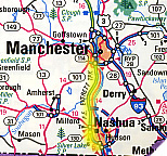
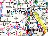
![]() Route 3 from Nashua to Manchester
Route 3 from Nashua to Manchester
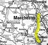
Just like Bypass 28 being a detour between Salem and Manchester rather than getting on the
highway, there is a detour between Nashua and Manchester. Route 3 can be used to travel
between Nashua and Manchester instead of the highway. It can be slow to travel but you
don't have to pay the toll so that in the long-run, it is buck-saving. After you leave
Nashua, you will pass by the beer factory, and then go through restaurants, plazas, houses
and buildings, which stand sparsely along the road. The town can go on several miles.
There is a little ice cream house on the left hand side, where President Bush stop by
before the campaign. You still have to head up north until you get to Bedford. You will
pass through little hills and woods and then finally you get to Bedford, which is adjacent
to Manchester. Make sure that you go over the bridge at the borderline of Bedford and get
onto Elm Street. If you go up north on Elm, you will get to the downtown Manchester.
![]() Route 3 from Manchester to a Diner located around Veteran Cemetry near the
fork of Route 3 and 4.
Route 3 from Manchester to a Diner located around Veteran Cemetry near the
fork of Route 3 and 4.
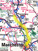
First of all, this road trip does not really have scenic views. Rather, it is the road
trip to go through some of the main cities in NH. From Manchester, you must drive toward
Hooksett. Take right at the last intersection on north Elm street, go straight on Route 3.
After Daniel Webster, Route 3 which connects Manchester to Hooksett, you will be in
Hooksett. It is a nice town, where country-styled lifestyle can be found. You may want to
stop at 99 for dinner. From Hooksett, you will go up north toward Concord. You are on the
right track if you pass a hunting store, in Hooksett, on the left hand
side. In Suncook, you will go up a hill after a bridge and keep on going straight through
a town of Penbroke. There is a traffic light within a few miles just before you go down a
hill. You stay on the route, go down and up a hill and keep on going straight. When you
come down a hill next time, you will realize that you are getting to a city. It is the
city of Concord. You go under highway, and keep on going straight. You will go across the
city. Some intersection might look tricky but stay on the same route. As you get away from
the city, within a few miles, there is a jail on the left. You might pass some town but
keep on going. There is a fork in several miles ahead. You take the left route there to
remain on the route 3. After you pass the residential area then, you will get to a curved
T intersection. You will turn left to merge onto the route coming from behind. This is
still the route 3. After a few miles, you will get to another fork route. This time, take
right to remain on the same route. You should realize that the other one is the route 4.
This is a woody region. From the fork, it is not that far until you get to the diner
located around Veteran Cemetry. The diner is located on the left hand, adjacent to a
motel. It has an atmosphere of a log cabin and they serve good Sunday brunch.
![]() Route 3 from Laconia to Meredith
Route 3 from Laconia to Meredith
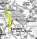
This is one of the famous routes for bikers. There are some biker's stops around Meredith.
The lake region is nice too. This is a popular route among bikers in the summer.
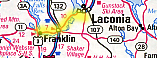
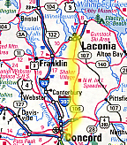
![]() Route 3 from Laconia to Franklin
Route 3 from Laconia to Franklin
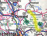
![]() Route 106 from Route 3 to Laconia
Route 106 from Route 3 to Laconia
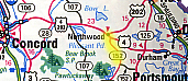
![]() Route 4/202 from Route 28 traffic circle to Portsmouth
Route 4/202 from Route 28 traffic circle to Portsmouth

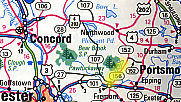
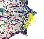
![]() Route 107 from Route 4 to Raymond
Route 107 from Route 4 to Raymond
![]() Route 152 from Route 4 to Lee
Route 152 from Route 4 to Lee
![]() Route 156 from Route 152 to Route 101
Route 156 from Route 152 to Route 101
![]() Route 33 from Route 101 to Greenland
Route 33 from Route 101 to Greenland
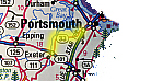
![]() Route 1A from Hampton Beach to Portsmouth
Route 1A from Hampton Beach to Portsmouth
![]() Route 102 from Route 101 to Nashua
Route 102 from Route 101 to Nashua
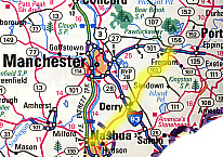
![]() Route 111 from Nashua to near Sandown
Route 111 from Nashua to near Sandown
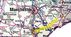
![]() Route 101 from Bedford to Milford
Route 101 from Bedford to Milford
![]() Route 13 from Milford to Goffstown
Route 13 from Milford to Goffstown
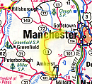
![]() Route 77 near Goffstown to near Henniker
Route 77 near Goffstown to near Henniker
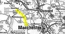
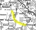
![]() Route 149 from Goffstown to Hillsborough
Route 149 from Goffstown to Hillsborough
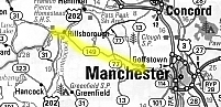
![]() Route 31 from Hillsborough to Route 10
Route 31 from Hillsborough to Route 10
![]() Route 10 from Route 31 fork to exit 13 on Route 89
Route 10 from Route 31 fork to exit 13 on Route 89
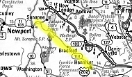
![]() Route 114 from Henniker to Sunapee Lake
Route 114 from Henniker to Sunapee Lake
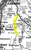
![]() Route 11/113 from Route 89 to Claremon
Route 11/113 from Route 89 to Claremon
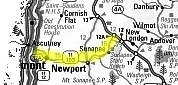
![]() Route 120 from Claremont to Lebanon
Route 120 from Claremont to Lebanon
![]() Route 109 from Wolfeboro to YMCA out of the town
Route 109 from Wolfeboro to YMCA out of the town

Referenced in "Easy-To-Read Travel Atlas (2000 Edition)", sold at Kmart